Your Partner for
Integrated Geophysics
and Geoscience Intelligence

Your Partner for
GeoScreening is a geoscience consultancy based in Oslo, Norway, specializing in transforming complex subsurface and spatial data into clear, reliable, and actionable insights. We deliver integrated solutions across applied geophysics, GIS, and remote sensing, supporting projects from initial investigation through advanced analysis and long-term monitoring.
Our expertise includes geophysical survey design, data acquisition, processing, and interpretation, using methods such as electrical resistivity tomography (ERT), ground-penetrating radar (GPR), magnetics, and seismic analysis. These capabilities are complemented by advanced GIS, photogrammetry, LiDAR, and drone-based workflows, enabling a unified understanding of both surface and subsurface conditions.
GeoScreening also develops automated and time-lapse monitoring solutions, including A-ERT systems and custom web-based platforms for data visualization and data management. Working across research, archaeology, environmental studies, engineering, and infrastructure, we bridge complex geoscientific data and informed decision-making through scientifically robust and practical solutions.
GeoScreening delivers scientifically robust geophysical and spatial analysis, grounded in applied research and real-world experience. Every project is approached with methodological rigor, transparency, and reproducible workflows.
We combine applied geophysics, GIS, photogrammetry, and LiDAR into unified spatial products. By integrating subsurface and surface data, we provide a complete geospatial understanding of complex environments.
Beyond one-off surveys, GeoScreening develops and supports monitoring systems, including automated solutions. Custom web interfaces allow clients to visualize and interpret results clearly, efficiently, and in near real time.
GeoScreening provides integrated geoscience services that transform complex spatial and subsurface data into clear, reliable, and actionable results. Our work combines scientific rigor with practical application, supporting projects from early investigation through advanced analysis and long-term monitoring.
We operate across three core service areas:
Targeted geophysical investigations delivering reliable subsurface insight through carefully selected methods, expert data acquisition, and integrated interpretation.
Integrated spatial analysis and remote sensing workflows that connect surface data, imagery, and geophysical results into coherent geospatial products.
Design and implementation of automated monitoring systems and data management solutions for time-dependent and long-term geophysical investigations.
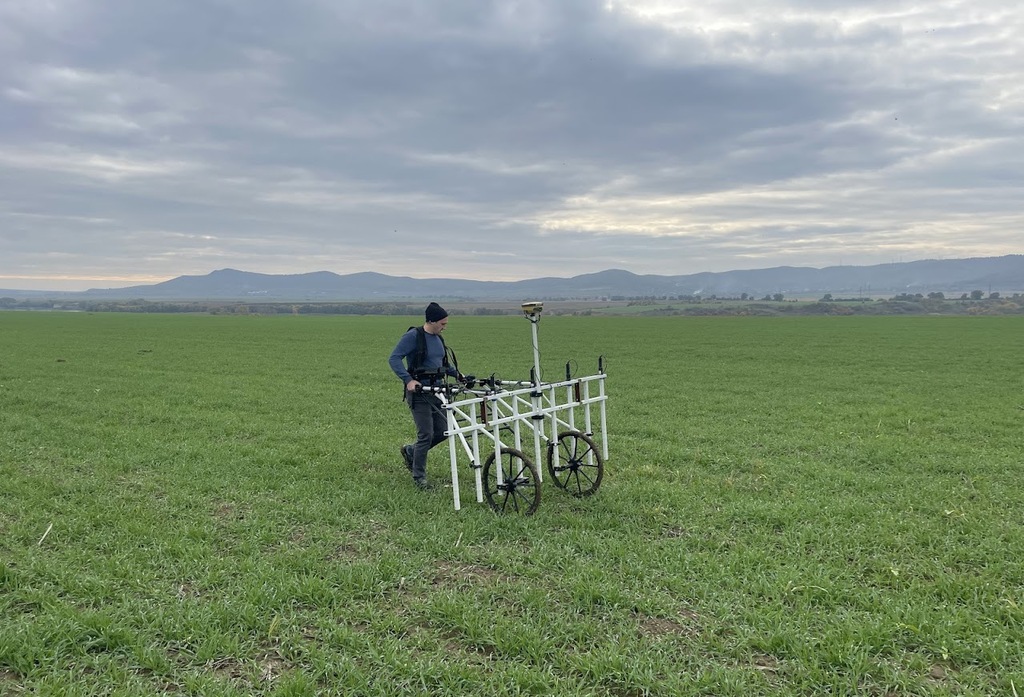
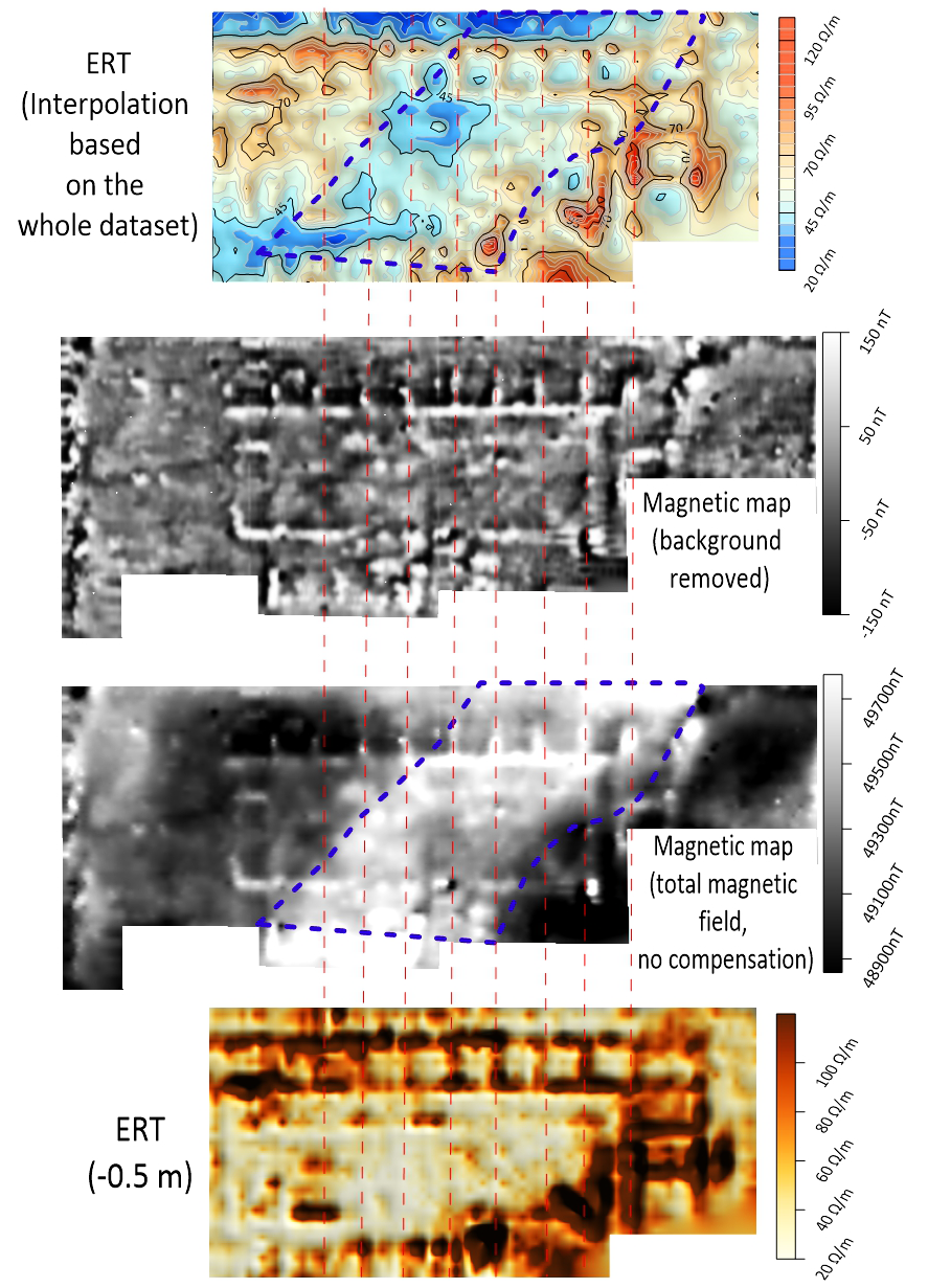
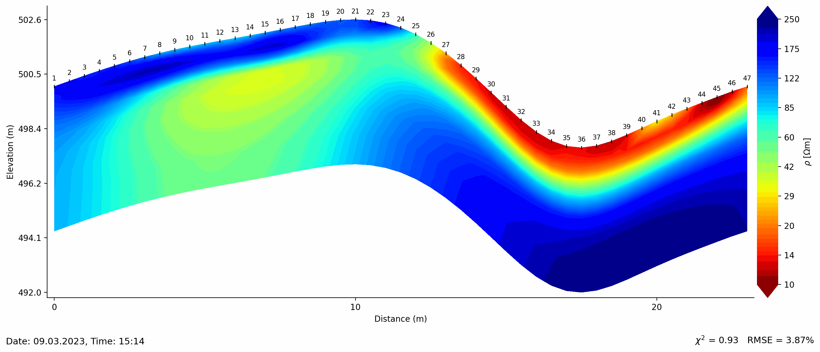
GeoScreening provides applied geophysical services designed to deliver reliable and meaningful insight into subsurface conditions. We support the full project lifecycle, from early-stage feasibility and method selection through survey design, data acquisition, processing, and interpretation.
Our expertise covers a broad range of geophysical methods, including ground-penetrating radar (GPR), electrical resistivity tomography (ERT), magnetics, and seismic data processing. Each project is approached with a methodologically sound strategy, ensuring that the selected techniques are appropriate for the site conditions, target depth, resolution requirements, and project objectives.
Data quality and interpretation are central to our work. We apply rigorous processing workflows and integrated interpretation to produce clear, defensible results that can be directly applied to engineering, environmental, archaeological, research, and infrastructure-related projects. Where required, we also provide on-site acquisition and technical consultancy to ensure efficient and robust survey execution.
By combining technical expertise with practical experience, GeoScreening delivers applied geophysical solutions that support confident decision-making and effective project planning.
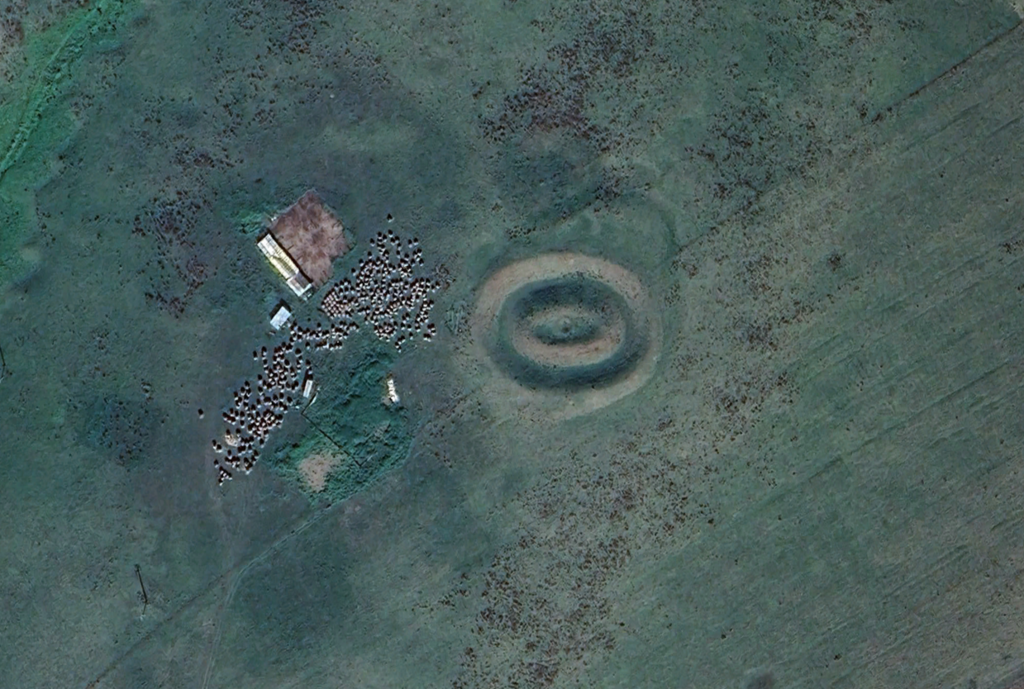
GeoScreening provides advanced GIS and remote sensing services that support the analysis, visualization, and integration of spatial data across a wide range of applications. Our workflows are designed to place geophysical results within an accurate and meaningful spatial context, enabling a comprehensive understanding of site conditions.
We work with a variety of data sources, including drone-based imagery, photogrammetry, LiDAR, and existing spatial datasets. These data are processed, analyzed, and integrated within GIS environments to produce high-quality maps, 3D surface models, digital terrain models, and spatial analyses tailored to project-specific objectives.
By combining geophysical information with robust spatial analysis, GeoScreening delivers clear and consistent geospatial products that support environmental studies, archaeology, engineering, planning, and research-driven projects.
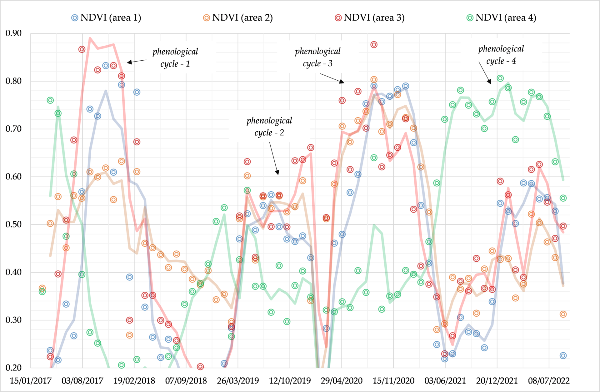
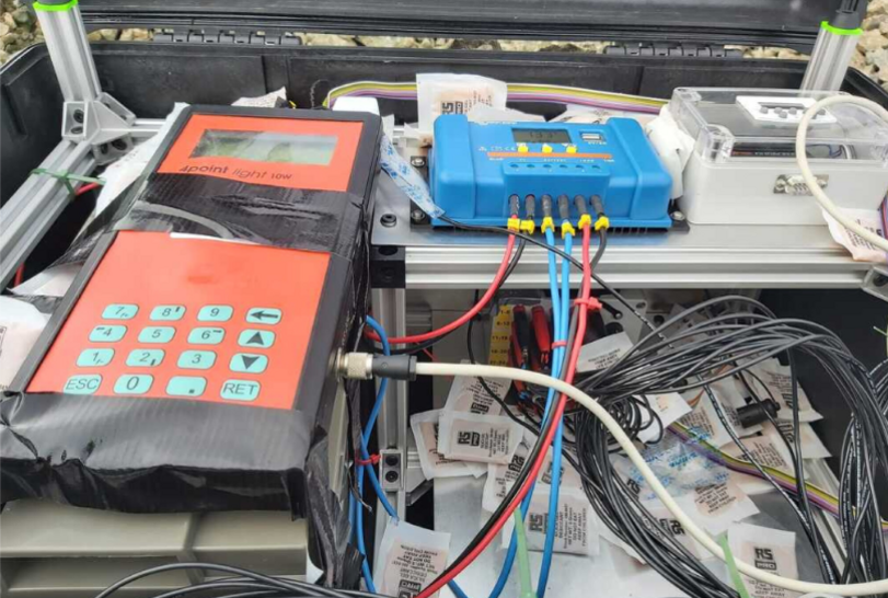
GeoScreening develops and implements monitoring and data management solutions that support continuous and time-lapse observation of subsurface processes. These services are designed for projects where understanding temporal change is critical, such as environmental monitoring, infrastructure assessment, and research applications.
Our expertise includes automated and time-lapse geophysical monitoring systems, including Automated Electrical Resistivity Tomography (A-ERT). We support the full workflow, from system design and deployment to data processing, quality control, and interpretation.
To complement monitoring activities, GeoScreening also develops custom web-based platforms that enable efficient data visualization, exploration, and management. These tools provide accessible and interpretable outputs, allowing stakeholders to track changes, evaluate trends, and make informed decisions based on reliable, continuously updated data.

Working with you to transform complex geoscience data into clear, actionable understanding.
Powered by HEGYI GEO Consulting | Org. number: NO937075898